A 19th-century Arctic map (see above) reveals how colonial cartography still frames today’s security debates. Hermann Berghaus’ Nord-Polar-Karte (1881) erased Indigenous presence, turning the Arctic into a space for European exploitation. This blog explores the map’s legacy and argues for a decolonial Swiss Arctic strategy that prioritizes local and Indigenous perspectives and challenges colonial narratives.
09.Juni 2026

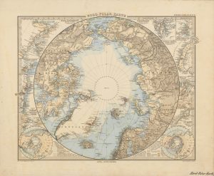
Source: Berghaus, Hermann. Nord-Polar-Karte. Justus Perthes, 1881.
When U.S. President Trump makes remarks about acquiring Greenland, or about securing „a piece of ice” he is not inventing a new frontier so much as tapping into a much older colonial script. For centuries, European and later North American powers have treated the circumpolar North as a storehouse of resources, a strategic military zone, and land to be claimed and controlled. But it was never “empty”: Inuit, Sámi, and other Indigenous peoples have long lived across the region. Hermann Berghaus’ Nord-Polar-Karte (1881) makes this script visible. The map shows detailed coastlines encircling a pale Arctic center, crossed by sea routes and expedition tracks. It appears to offer an objective overview of the North Polar Region. Yet, the emphasis on European voyages and the absence of Indigenous place names reveal its imperial purpose: the Arctic as a space for European navigation, not Indigenous life.
Published in 1881, the Nord-Polar-Karte emerged at a time when the Arctic had become a zone of imperial rivalry. It was not just a record but a tool. Mapping coastlines, soundings, and sea lanes helped shift attention from reaching the Arctic to exploiting it. The map shows a network of European voyages like the British Northwest Passage expeditions (1850–1853) and the German North Polar Expedition (1869–1870). Indigenous peoples like Inuit, Iñupiat and Sámi are erased; their homelands reduced to European-named coastlines like “Greenland” instead of Kalaallit Nunaat; cross-border migration routes of Sámi reindeer herds stay invisible on the map. The Arctic Ocean becomes a grid of potential shipping routes, while the polar interior is rendered as a blank disc, awaiting future claims.
Whose Security Matters?
Berghaus’ map did not just reflect geopolitical realities but helped create them. By framing the Arctic as a space of chokepoints and sea lanes, it laid the groundwork for today’s debates about the Northwest Passage, NATO’s “northern flank,” and offshore resource extraction. Contemporary discussions about year-round shipping and military infrastructure echo the map’s logic: the Arctic as a strategic corridor, not a homeland.
A feminist-decolonial lens asks a different question: “whose security matters”? The map clearly prioritises the safety and mobility of imperial actors over the people who already inhabit these coasts. The asymmetry is reinforced by what it leaves blank. Rather than reading the white polar disc in the centre as ´unknown,´ a feminist-decolonial perspective suggests understanding it as produced emptiness: a visual effect that clears conceptual space for future scientific, economic, or territorial claims, by depicting the region as unoccupied and unowned. Doctrines of terra nullius drew on such cartographic and legal imaginaries of emptiness to argue that polar lands and seas could be taken into imperial possession because no recognized owners or political communities appeared on European maps.
Policy Recommendations: Toward a Decolonial Swiss Arctic Strategy
Today’s debates about sovereignty and Indigenous rights in Arctic governance still reflect old ways of mapping the region. When Trump speaks of securing “a piece of ice,” it echoes this view: the Arctic as strategic space first, and a lived Indigenous homeland only at the margins. Reading Berghaus’ Nord‑Polar‑Karte alongside such statements shows how sea routes and ‘empty’ centres on a nineteenth‑century atlas sheet continue to inform twenty‑first‑century struggles over sovereignty, resources, and whose futures in the Arctic are meant to be secured.
Switzerland, though not an Arctic state, has long-standing ties to polar exploration and plays an active role in Arctic research, environmental monitoring and science diplomacy. Switzerland shows its Arctic commitment through the FDFA, the Swiss Polar Institute and its observer status at the Arctic Council. Yet Switzerland has no stand‑alone Arctic strategy, and the current approach remains largely technocratic, with little public debate on how Swiss engagement should reflect Indigenous rights and decolonial perspectives.
A decolonial Swiss Arctic policy could address this gap by systematically including Indigenous knowledge in Arctic‑related research and diplomacy; by actively supporting Indigenous peoples‘ participation and rights in international Arctic forums; and by ensuring that Swiss‑funded Arctic projects are designed in genuine partnership with local and Indigenous communities.
The maps we draw and the policies we draft, whether in 1881 or today, reflect whose voices we choose to include. The Arctic is not just a security buffer or a resource frontier. It is a homeland, and its future must be shaped by those who call it home.